Northwest Passage Weather Forecast Notes, 2012
This is about weather forecasts in Arctic North America and Western Greenland from the perspective of a small boat sailing in these areas. Details of the equipment used for receiving weather forecasts on my boat, Issuma, are at Weather Forecasts on Issuma
GRIB Forecasts:
GRIB forecasts are available everywhere if you have the ability to receive them.
Issuma lost the ability to receive GRIB forecasts when the Iridium satellite
phone failed in the middle of the Northwest Passage.
In Arctic Canada in 2011, I noticed the GRIB forecasts (using the GFS model) for quite a while were correct on the direction of wind, but unusually underestimated the speed. Normally with a GFS GRIB forecast, with wind speeds less than 30 knots, I consider the forecast to be up to 50% higher (ie, if the forecast speed is 10 knots, I expect 10-15 knots, if the forecast speed is 15 knots, I expect 15-22 knots). What I saw in Franklin Strait and Victoria Strait was often GRIB forecasts for 2-7 knots and actual wind speeds of 12-20 knots (the wind directions were correct, the speeds were just way low).
Weatherfaxes:
Weatherfaxes covering much of Greenland are broadcast by The UK Weather Office
National Weather Service (USA) weatherfaxes, which forecast conditions up to 96 hours away, go up to 60 degrees N in the Atlantic. Beyond that, to some extent, location and movement of lows and highs can be inferred from them.
Canada broadcasts weatherfaxes for Eastern Canada, but, as the National Weather Service faxes from Boston cover the same area, go out farther, and are much easier to read (thicker lines, less information), I did not use them.

Image downloaded from internet, not received from weatherfax receiver
Canada broadcasts an Arctic Surface Analyis weatherfax (above) and a short-term expected wind map from VFF Iqaluit. The Arctic Surface Analysis for quite a while in the Northwest Passage was our main source of weather information, and it provides a lot of information, as it covers the whole Arctic, not just northern Canada. We started receiving the Arctic Surface Analysis weatherfax in the Labrador Sea, and continued to receive it until near Nunivak Island in the Bering Sea. Canadian weatherfax charts take quite a bit of looking at to figure out what is one is looking at (ie, where Canada is in relation to all the various isobars and reporting station ids, as there is a lot of data on their weather maps and the lines are thin), especially with the noise that reception via HF radio adds to the images. I struggled for quite a while trying to figure out what I was looking at. The lesson here is to download one of these from the internet, and get used to the format before trying to read one from a weatherfax receiver.
National Weather Service weatherfaxes from Kodiak, Alaska cover all of Alaska and go a long way west (so you have some idea of what is coming later). We were able to start receiving these weatherfaxes in Amundsen Gulf, northern Canada (125 degrees West), and had good reception of them in much of Alaska.
Forecast Areas:
To use official forecasts or ice conditions via NAVTEX, you must know what the
forecast areas are.
For Greenland, see the DMI site
For Canada, you want the maps from the Canadian Coast Guard's Radio Aids to Marine Navigation, both the Atlantic and Pacific versions. Freely downloadable from Canada Coast Guard Radio Aids to Marine Navigation
For Alaska, you want the (outdated and no longer supported, but still useful to understand which forecast areas are where) Marine Service Charts
NAVTEX:
Labrador forecasts available over NAVTEX from Cartwright, Labrador, go pretty
close to Greenland (East Labrador Sea forecast area), as do the Nunavut forecasts
on NAVTEX from Iqaluit (East Brevoort, East Davis, East Clyde, East Baffin,
Clarence forecast areas).
Greenland broadcasts gale warnings (in metres per second, for winds 15m/s or more) on NAVTEX, but not forecasts or ice conditions.
NAVTEX forecasts for Alaska are broadcast from Kodiak and Juneau. We had spotty reception of NAVTEX in Northern Alaska and good reception from most of Alaska.
Only short-term (36hour) weather forecasts are put on NAVTEX in Canada and for coastal areas in Alaska. The VHF Weather Channel forecasts in Alaska go out 5 days.
VHF Radio Forecasts:
In Greenland, gale warnings are broadcast on VHF radio in Greenlandic and Danish
(and English, if I recall correctly). Forecasts are not broadcast on VHF.
In Canada and the USA, VHF radios are sold with several extra channels on them. These extra channels provide continuous (repeated) broadcasts of weather information and are also used by the Coast Guards.
The Canadian Coast Guard, on their dedicated channels, read out forecasts and outlooks continuously (along with local notices to mariners). The Canadian Coast Guard VHF transmitters do not cover the entire east coast, but when within range of one, they are excellent to listen to.
There are a few (see the Marine Weather Services brochures mentioned in above in Official Forecasts for details) VHF weather transmitters in Northern and Western Alaska, more are in Eastern and Southeastern Alaska.
Ice Conditions:
Alaska Ice Forecasts are at NWS Alaska Sea Ice Program
Alaska broadcasts ice charts (as faxes) from Kodiak and NAVTEX texts of ice
information as well.
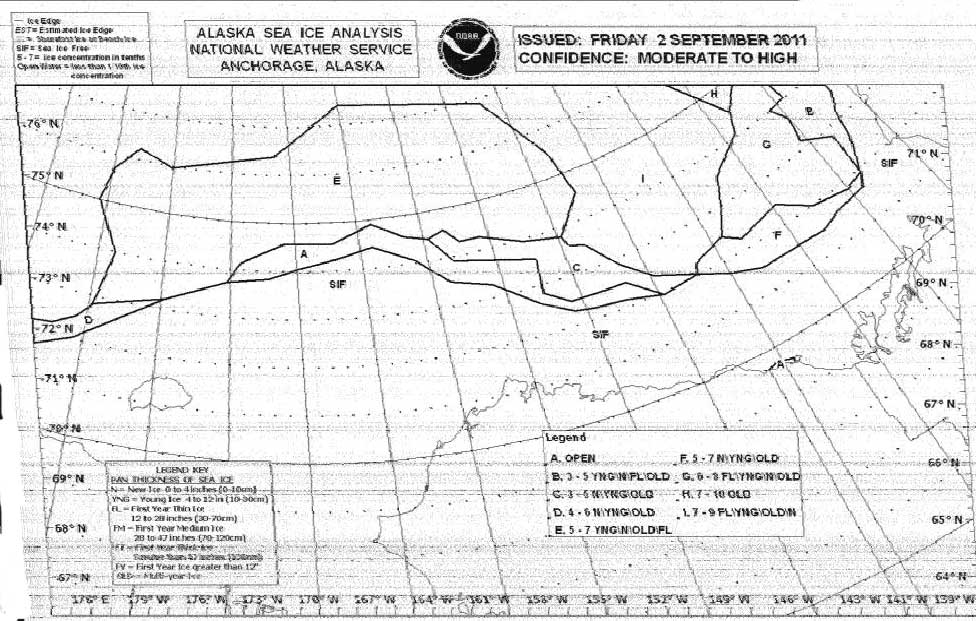
Image received from weatherfax receiver
Canada has ice charts at Latest Ice Conditions
Canada broadcasts ice condition charts regularly on HF fax and also (as text) on NAVTEX. Canada's transmitter in Resolute, Nunavut broke down in 2011, so we were not always able to receive ice charts via HF or NAVTEX. I'm not sure of the status of Inuvik transmitter facilities, however we received no weatherfaxes or NAVTEXs from VFA Inuvik. For the eastern Arctic, and part of the way into the central Arctic, VFF Iqaluit provided both ice charts and NAVTEX ice texts.

Image received from weatherfax receiver
Danish Meterological Institute has ice charts of Greenland at Ocean and Ice Services
| Home | Issuma | Orbit II | Rosemary Ruth | Presentations | Contact |